字體:小 中 大
 |
|
|
|
| 2018/02/07 10:08:44瀏覽1280|回應4|推薦46 | |
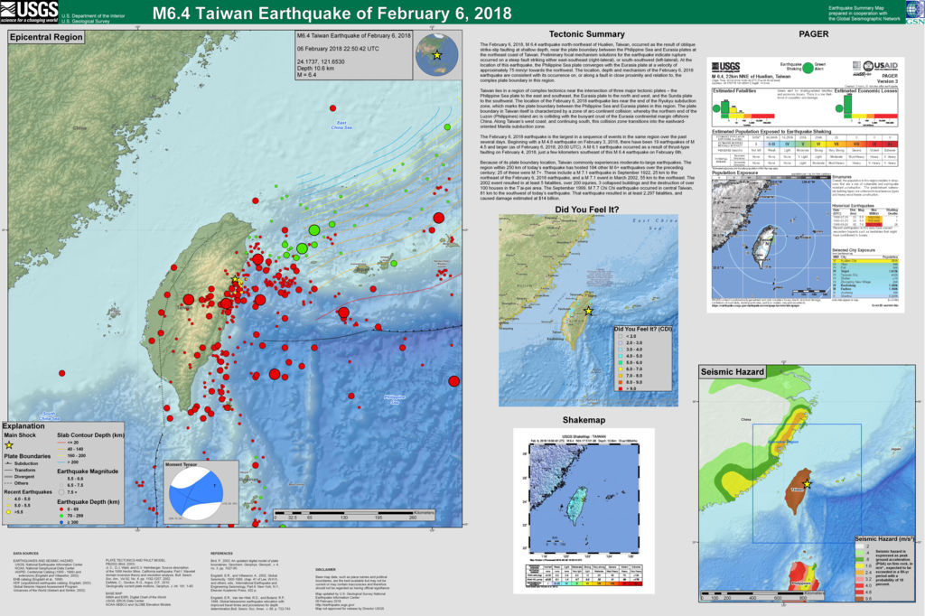
100年來台灣附近發生的大地震(圈圈大小代表強度) 圖片來源: 前年2月6日高雄美濃發生6.4級地震,引起房屋倒塌,死傷慘重。沒想到隔了兩年,剛好同一天,震央移到花蓮北北東方,又是6.4級,而且花蓮、宜蘭的震度達到七級。強震之後餘震100多次,氣象局還警告,不排除更大的地震 ! 據新聞報導花蓮有四棟大樓傾斜,兩座橋樑封閉;2人罹難,100多人受傷。悼念不幸的罹難同胞,也希望其他地方沒有這樣的損失。(隔了一天的新聞是8人去世,200多人受傷)。 打電話給媽媽,老人家睡得早,沒有感覺到,還以為我問的是前兩天的地震。最近世界多處地震,還有一兩個火山爆發,地球真不平靜啊。 抄一下美國地質調查局的報告,中央氣象局大概有中文講解。 Tectonic Summary The February 6, 2018, M 6.4 earthquake north-northeast of Hualien, Taiwan, occurred as the result of oblique strike-slip faulting at shallow depth, near the plate boundary between the Philippine Sea and Eurasia plates at the northeast coast of Taiwan. Preliminary focal mechanism solutions for the earthquake indicate rupture occurred on a steep fault striking either east-southeast (right-lateral), or south-southwest (left-lateral). At the location of this earthquake, the Philippine Sea plate converges with the Eurasia plate at a velocity of approximately 75 mm/yr towards the northwest. The location, depth and mechanism of the February 6, 2018 earthquake are consistent with its occurrence on, or along a fault in close proximity and relation to, the complex plate boundary in this region. Taiwan lies in a region of complex tectonics near the intersection of three major tectonic plates – the Philippine Sea plate to the east and southeast, the Eurasia plate to the north and west, and the Sunda plate to the southwest. The location of the February 6, 2018 earthquake lies near the end of the Ryukyu subduction zone, which marks the plate boundary between the Philippine Sea and Eurasia plates in this region. The plate boundary in Taiwan itself is characterized by a zone of arc-continent collision; whereby the northern end of the Luzon (Philippines) island arc is colliding with the buoyant crust of the Eurasia continental margin offshore China. Along Taiwan’s west coast, and continuing south, this collision zone transitions into the eastward-oriented Manila subduction zone. The February 6, 2018 earthquake is the largest in a sequence of events in the same region over the past several days. Beginning with a M 4.8 earthquake on February 3, 2018, there have been 19 earthquakes of M 4.5 and larger (as of February 6, 2018, 20:00 UTC). A M 6.1 earthquake occurred as a result of thrust-type faulting on February 4, 2018, just a few kilometers southeast of this M 6.4 earthquake on February 6th. Because of its plate boundary location, Taiwan commonly experiences moderate-to-large earthquakes. The region within 250 km of today’s earthquake has hosted 184 other M 6+ earthquakes over the preceding century; 25 of these were M 7+. These include a M 7.1 earthquake in September 1922, 25 km to the northeast of the February 6, 2018 earthquake, and a M 7.1 event in March 2002, 55 km to the northeast. The 2002 event resulted in at least 5 fatalities, over 200 injuries, 3 collapsed buildings and the destruction of over 100 houses in the T’ai-pei area. The September 1999, M 7.7 Chi Chi earthquake occurred in central Taiwan, 81 km to the southwest of today’s earthquake. That earthquake resulted in at least 2,297 fatalities, and caused damage estimated at $14 billion. 相關文章: " 2月6日南台灣大地震" |
|
| ( 心情隨筆|心情日記 ) |